
256 Street Industrial Area Plan Approved (June 2026)
On June 23, 2026 Council approved amendments to the Official Community Plan (OCP) to create the North 256 Street Industrial Lands Area Plan—formalizing a new approximately 500-acre economic hub in northeast Maple Ridge that will help address the region’s shortage of industrial lands. Details are in our June 24, 2026 News Release and in the June 23, 2026 Council report.
For more details on the development of the area plan, visit our engagement page at Engage.MapleRidge.ca/256AreaPlan.
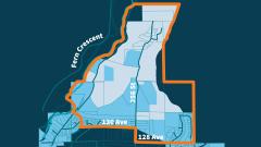
An area plan focusing on industrial use was developed for the lands north of 256 Street.
Description
The project included completing an area plan for the North 256 Street Industrial Lands to facilitate its development largely for industrial use, while recognizing long-standing institutional users, potential new associated or supportive uses and amenities, and existing environmental features and recreational activities in the area. This initiative aims to transform underused land in northeast Maple Ridge into a modern light industrial hub, supporting local job creation, economic diversification, and long-term tax stability.
Council Presentations
All documents can be viewed on the Council Meetings & Documents page.
- Jan 27, 2026: Council Report and Presentation Proposed Area Plan and Amendments to Official Community Plan (third reading)
- Jan 6, 2026: (First and Second Readings) Proposed Area Plan and Proposed Amendments to Official Community Plan
- Feb 18, 2025: North 256 Street Industrial Lands Area Plan Scope of Work
- Feb 18, 2025: Attachment A: Subject Area Map
Related links
- Industrial Lands Webpage
- News Release - January 7, 2026 - Phase 3 Engagement Launch
- News Release - November 25, 2025 - Phase 2 Engagement Results
- News Release - September 26, 2025 - Phase 2 Engagement Launch
- Info Bulletin - July 9, 2025 - Phase 1 Engagement Results
- News Release - April 15, 2025 - Phase 1 Engagement Launch
- News Release - February 27, 2025 - Project Launch
- 251127-Environmental and Hydrogeological Assessment-North 256 Street Industrial Lands Area Plan-FINAL-V1.1 [PDF/27.9MB]
- Metro 2050 Type 2 Proposed Amendment, Bylaw No. 1451, 2026 – City of Maple Ridge (North 256 Street Industrial Lands Area Plan)
- Development Permit Area Guidelines Chapter 8.17 [PDF/1.4MB]
- Area Plan Chapter 10.7 [PDF/3MB]