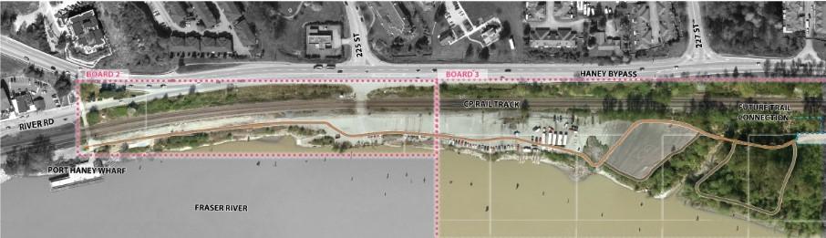
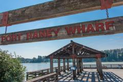
A new riverfront Multi-Use Pathway in Port Haney, extending from Port Haney Wharf to Kanaka Creek Regional Park.
Description
In 2021, the City of Maple Ridge acquired a 5-acre riverfront site in Port Haney, formerly used as a log sort area. Located between the CPKC Rail tracks and Haney Bypass to the north and the Fraser River to the south, the site will be transformed into a public waterfront corridor.
The first phase of this project will create a new multi-use pathway that supports walking, cycling, running, and rolling in a safer, more accessible setting separated from road traffic.
The project will:
improve access to the waterfront
enhance connections to parks, trails, and key destinations
support recreation, wellness, and active transportation
create a safer route separated from vehicle traffic
provide a more accessible public space for people of all ages and abilities
support community connection, tourism, and local economic activity
contribute to environmental sustainability
This pathway is part of the long-term vision for Experience the Fraser, a regional initiative to create a connected trail network along the Fraser River. Please note that the trail connection to Kanaka Creek Regional Park will be completed by Metro Vancouver and may not be open at the same time frame.
Construction is starting on the new Port Haney Multi-Use Pathway (MUP). We anticipate that the pathway will be open in spring 2027 if construction proceeds as anticipated. For more details, visit Enage.MapleRidge.ca/PortHaneyMUP.
Construction timing has not yet been finalized.
Once construction details are confirmed, the City will share information about:
What is a Multi-Use Pathway? Multi-use pathways (MUP) are dedicated routes or corridors that accommodate various modes of non-motorized, active transportation and recreational activities. These pathways are typically separate from roadways, providing a safe and accessible environment for pedestrians, cyclists, runners and small wheeled modes of transport.
Why just a multi-use pathway and not a waterfront park? The multi-use pathway is anticipated to be the first phase of a larger park development at the site. During our first round of community engagement, we asked for ‘big ideas’ for this future stages of this park development. Top “Big Ideas” included:
Food & drink
Shops & Market Spaces
Improved access to waterfront park site
Dog off leash area
Playground
When will this be open? We anticipate that the multi-use pathway will be open in summer 2027 if construction proceeds as anticipated.
Why has construction of this project been delayed? While the project goals are straightforward, the process has been complex because of the project location. The project property is uniquely positioned between the Fraser River, the CPKC rail track, and Port of Vancouver Lands. These features create some complicated conditions that have resulted in an extended project timeline. The river is a beautiful natural feature with important environmental functions and cultural heritage that we need to respect and protect. This means working with many organizations that have interests in the area, which includes various levels of government and local First Nations. Each of these organizations has their own priorities and requirements.
Some of the steps we’ve had to take before moving into construction include:
Obtaining environmental permits from the Province, Fisheries and Oceans Canada (Federal), and the Port of Vancouver Port Authority.
Conducting an ‘Archaeological Impact Assessment’, a field investigation conducted by a professional consulting archaeologist, with permission and in consultation from the local First Nations.
Lease agreement for use of Port of Vancouver Lands
Agreement with CP rail to ensure a safe public crossing over their rail line at the entrance to the future park site.
Application with the province’s Ministry of Transportation and Transit for permission to make changes to the Haney Bypass & to provide safe access into the site.
How has the design changed and why? Since our last community engagement, the multi-use path alignment and site features have been finalised into a detail design ready for construction. We’ve made a few minor changes in response to environmental regulations and towards improving user experience.
Parking: A formal visitor parking lot has been added to the plan. This will provide parking for those who want to access the pathway or enjoy the views from the lookout and river front seating. It also will provide accessible permit parking spaces and support the future park amenities.
Pathway changes: The secondary gravel path loop through the forested area at the east of the property was removed to retain more trees and limit disturbance to environmentally sensitive areas.
Path lighting: Lighting has been added along the pathway, outside of the wooded areas. This will improve safety and hours of use in the darker month of the year.
Erosion control: Boulders and large rip-rap will be placed at points along the shoreline to protect the pathway and site against erosion.
Restoration planting: Native tree and plant species will be planted along the shoreline to improve the riverfront ecosystem and compensate for the areas where project construction may impact existing vegetation.
Entrance Improvements: Modifications will be made to the roadway and rail crossing to provide safe public access into the property. The changes to the road will be minor and will have minimal impact on traffic.